Location: Monument Mountain
Nearby Town: Great Barrington, MA
Elevation (Max): 1,642'
Elevation Gained: 720'
Mileage: 3
Difficulty: Moderate to Strenuous
Trailhead: From intersection of Rts. 7 and 102 in Stockbridge center (Accessible from either Exit 1 or Exit 2 off I-90, the Massachusetts Turnpike), Take Rte. 7 South and follow for 3 mi, Entrance and parking are on right. From Great Barrington, Take Rte. 7 North and follow for 4 mi. to entrance and parking on left.
Website: http://www.thetrustees.org/places-to-visit/berkshires/monument-mountain.html#t1
This hike is in a different league from any of the previous ones I've done. Not only is it more than 1,000 feet higher in elevation than previous hikes, but it also features several cliffs, which present no danger as long as a little common sense is used (i.e. don't walk off them). E and I did this hike with our good friend Wanda while we were all on our way to the Hudson River Valley to celebrate a friend's birthday. Seeing as her birthday is February 4, and this hike is in the Southern Berkshires, we knew we had some cold to deal with. First, though, a little background.
Monument Mountain is another beautiful area, like Noanet Woodlands, maintained and protected by the Trustees of Reservations. The reservation sees a lot of visitors averaging about 20,000 per year. Since we were hiking in the dead of winter with about ten inches of snow on the ground, though, we only encountered one other person on the hike, a snowshoer (and his dog). Perhaps the most famous visitors to the mountain, though, were Herman Melville and Nathaniel Hawthorne who made the trek together in August, 1850. When a thunderstorm struck, they sought refuge in a cave where they had a vigorous discussion that helped inspire ideas for Melville's new book, Moby Dick.
There were no thunderstorms for our hike, but it was awfully cold. My thermometer read 22 at the base, but the stiff wind brought the wind chill down to the single digits (and, of course, less on the summit). The hike, however, was absolutely gorgeous and thoroughly enjoyable. There are basically two ways to ascend Monument Mountain, Indian Monument Trail (the long way) or the Hickey Trail (the short way). The former makes a loop around to the west side of the mountain which is significantly less steep than the almost sheer east side which the Hickey Trail ascends. Whichever trail you choose, you will need to take the Squaw Peak Trail to actually reach the summit.
We decided to do a circuit of all three trails, ascending via the Hickey Trail, taking the Squaw Peak Trail to the summit and Squaw Peak (a rocky outcropping), and descending via the Indian Monument Trail. Therefore, at the trailhead, take a right. The trail, despite what the topographical maps seem to indicate was not overly steep. In fact, we found the trail to be surprisingly easy. This was probably the result of two forces at work. First, the beauty and quiet of a snow covered mountain forest is breathtaking and helps to soften the pain and burning of a strenuous climb. Second, as I mentioned earlier, we were hiking on a thick snow cover, which was somewhat packed down on the trail, but since it was not hard packed, it provided protection from tripping on roots and rocks without the downside of lost traction. It's amazing how much energy you save when you aren't constantly dodging roots and rocks. Also, despite the fact that we could see the very steep sides of the mountain looming above us for almost the entire ascent, we seemed to reached the summit without confronting them--very clever trail placement.
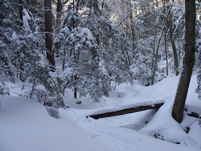
The Hickey Trail is pretty easy to follow; there are no intersecting trails until you reach the junction with Indian Monument and Squaw Peak. Along the way, we enjoyed the beautiful streams running through the snow, caves covered in icicles, and drooping evergreen boughs covered in snow. When you reach the junction with Indian Monument and Squaw Peak, keep left on Squaw Peak which will take you to the true summit (1,642') and beautiful Squaw Peak (1,640'). From Squaw Peak you can see the Catskills to the west, Berkshires all around you, and north to Mount Greylock near the Vermont border. Once you've soaked in all the beauty you can, continue hiking in the same direction as before (south) which will descend pretty steeply for a little bit until you reach Indian Monument Trail at which point you will want to go left to return to the parking lot. Below are a bunch of photos from our hike. Enjoy.
 At the start. Brrrrr, handwarmers a must
 Beauty along the Hickey Trail
 Multicolored icicles and a cave
 Nearing the Squaw Peak Trail
 Mount Greylock to the north
 Officially summitted
 Looking west to the Catskills in the distance
 Be careful of steep dropoffs
 On Squaw Peak
 Looking east at the near hills


Looks awesome! I think I'll take my group here this weekend. Thanks for the idea!
ReplyDelete