Hike: The Lake Trail
Nearby Town: Cary, NC
Elevation (Max): ~300'
Elevation Gained: ~160'
Mileage: 6.06
Difficulty: Easy
Trailhead: Take Exit 285 off I-40. Turn west on Aviation Pkwy (away from the airport). Entrance to the park will be on the left across from Gateway Centre. Park in the last parking lot and the trailhead is off the driveway connecting the lot to the park road.
Web Site:
http://www.wakegov.com/parks/lakecrabtree/default.htm
If you're looking for an escape from the subdivisions and office parks of Cary and Morrisville, greenways are great options, but an even better one may be Lake Crabtree park. The blue-blazed Lake Trail hikes around the entire perimeter of Lake Crabtree negotiating trails in the woods, boardwalks over low lying areas, and paths along some busy roads and behind office parks in Cary and Morrisville. The first part of the trail is also a mountain biking trail so watch out for bikers especially around the hills near the beginning. The trail splits a couple times, but you can keep from getting lost if you stay right at all splits to remain along the lake.

 A view toward the dam
Not long after descending the hills at the beginning, the trail comes to the Heather Carr Memorial Overlook which provides a place to sit and observe the lake--Heather Carr was essential in creating the Lake Trail. The trail then curves along the lakeshore, right next to I-40, and then up the dam that creates Lake Crabtree. At this point, the trail joins Cary's Black Creek Greenway which is a paved path.

 Dam outflow
Another observation deck/gazebo is on the greenway with a water fountain (and doggy water fountain). When the greenway reaches Weston Parkway (it's the bridge above), the Lake Trail splits off on a bridge over Black Creek on the right. From this point onward, the trail can be poorly marked, yet I never got lost just using my gut, and I trust most people will have the same luck. Like I mentioned before, as a general rule, go toward the lake at junctions and Ys ,and you will be okay.
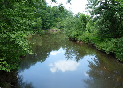 Black Creek

 Low-lying area
 Hidden trail directly next to Evans Road
The trail winds through low lying areas that would probably be wet during rainy times but were completely dry when I went through. The trail then walks along Evans Road on a path tucked in some small trees before emerging to cross Crabtree Creek over a bridge. Next, the trail walks between the offices at Southport and the Lake for a little while before turning into the woods and emerging to walk along Aviation Parkway. Unlike Evans Road, the trail along Aviation Parkway is exposed with no tree cover and was extremely hot when I did the hike in the middle of summer. The trail then turns right into the woods and soon emerges into an open field which leads to a parking lot. If you parked here, then congratulations, you've completed the Lake Trail. If you parked by the trailhead, though, you need to walk right along the park road a bit to return to your car. A hike around Lake Crabtree is an interesting mix of urban and natural, and it provides a nice, new perspective of some areas that many of us drive by everyday. Below are several pictures and a GPS-generated map of the hike.
 Bridge (above) over Crabtree Creek (below)

 Boardwalk leading to Aviation Parkway


 A view toward the dam
 Dam outflow
 Black Creek
 Low-lying area
 Hidden trail directly next to Evans Road
 Bridge (above) over Crabtree Creek (below)
 Boardwalk leading to Aviation Parkway


